
SHIMSHAL
“On the whole I was agreeable surprised at the village, which must be almost the most remote and inaccessible place in the Indian Empire, cut off as it is from the outer world, and hardly visited by anyone, native or foreign.”[1], Schomberg noted when he reached Shimshal in 1934.
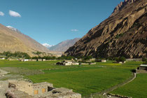
It was exactly this isolation and difficulty of access, that preserved their unspoilt culture and kept centuries old traditions alive. Shimshal Valley itself is situated at a height of 3.200m, divided into three settlements along the valley. The origin of its inhabitants is believed to be in central Asia from where they moved into Pakistan through Wakhan Corridor. The local language is Wakhi and their belief is Shia-Ismailism following the Aga Khan. Shimshal`s economy depends on self-sufficient agriculture and especially on livestock breeding. Fertile ground for farming is scarce and restricted only to the main valley. The hidden high mountain side valleys offer good summer pasture grounds, which allow successful transhumance livestock herding of sheep, goats and yaks. Shimshal is famous for their yak herds and once a year locals celebrate Woolio – their own festival with a yak race at Shimshal Pass.
On his Shaksgam Expedition in 1937 Shipton describes Shimshal: „In all our dealings with the Shimshalis, we met with kindness, courtesy and good humour. The community of Shimshal is remarkable for its isolation and independence of support from the outside world. From any direction the country is difficult of access, but the have sufficient arable land and grazin (…). They grow barley, wheat and peas, the flour of which, with cheese, butter and curd is their staple food. They do not grow many vegetables. They are a strong and healthy race. They are a happy community leading an ideal existence in magnificent surroundings. The country is sufficiently difficult, and conditions sufficiently severe, to foster in the people that hardihood without which it seems to me impossible for mankind to be content.[2]”
Shimshal is surrounded by mighty peaks, to the north by Karun Koh (7.164m) and to the south by the Muztagh Group with its massive peaks above 7000m such as Bularung Sar (7.134m), Lupghar Sar (7.200m), Malangutti Sar (7.207m), Yazghil Dome (7.324m), Momhil Sar (7.343m), Pumari Chhish (7.492m), Yukshin Gardan Sar (7.530m), Trivor (7.577m), Kanjut Sar (7.760m), Kunyang Chhish (7.852) und Disthagil Sar (7.885m). The huge ice falls and glaciers coming from those mountains feed the Shimshal river and thus are the basis of all life in the valley. But at the same time, their uncontrollable force represents an immanent threat to all life.
Exactly here, Visser realized on his expedition in 1925: “Here in the high mountains, where hardly any animal can breathe and hardly any vegetation grows, here I feel the life of nature much more than anywhere else on earth. Here I feel the creating elementary power surrounding me, the same power, that effects the endless space, here I feel it cumulated in these masses of ice that shift forward with giant force, here I feel it close by me as a feather light snow flake, which gives new energy to the glacier, here I feel it quaking in these mountains.”[3]
How close the incredible beauty of this alpine world and its wild force of nature with its uncontrollable hazards lie next to each other can be seen in the bitter regularity, when the glaciers naturally dam their rivers to huge glacier lakes, just to burst into a catastrophic flood, which unstoppably flows into the valley destroying everything that comes into its way: bridges, houses and major parts of the scarce farming ground. Everything gets destroyed and swept away.
In 1905 cultivated land in Pasu was lost owing glacial advances in the Shimshal valley in general and by the Malangutti and Khurdophin glaciers in particular. Followed by a further flood in 1906 leading to heavy destruction suffered in villages downstream as Pasu, Hussaini, when Hunza river rose 50feet above summer level and at Bunji the Indus rose 30feet due to the Shimshal flood.[4]
Visser was told; „that around ten years ago (approx. 1915) the whole village of Shimshal was swept away by a flood.”[5]
Another flood is recorded as „destroying many terraces and half of the original clustered settlement in 1964”[6], the traces of this catastrophy are visible till today. This flood occured possibly by a glacier dam burst of the Virjerab as
Kreutzmann mentions: “In the 1960s the name of Virjerab glacier in the Shimshal valley became synonymous with destruction”[7] eroding/washing out fields, roads and houses of villages as far as the lower settlements south of the confluence of Shimshal and Hunza
river.
Between 1884 and 1959 alone, more than eight major floods in the Shimshal valley have been recorded.[8]
[1] Schomberg, R.C.F., Unknown Karakoram, 1934.
[2] Shipton, Eric: Blank on the Map, 1938, in: Shipton, Eric: The Six Mountain Travel Book, 2012, p.296.
[3] Visser, Ph. C.: Zwischen Karakorum und Hindukusch, Leipzig 1928, p.169.
[4] Kreutzmann, Hermann, “After the flood. Mobility as an adaption strategy in High Mountain Oases. The case of Pasu in Gojal, Hunza Valley Karakoram.”, Die Erde 143 2012 (1-2), p.61
[5] Visser, Ph. C.: Zwischen Karakorum und Hindukusch, Leipzig 1928, p.169.
[6] WWF for Nature Pakistan, Socio-economical Survey of Shimshal Valley, Hunza, Gilgit, p.7
[7] Kreutzmann, Hermann, “After the flood. Mobility as an adaption strategy in High Mountain Oases. The case of Pasu in Gojal, Hunza Valley Karakoram.”, Die Erde 143 2012 (1-2), p.62 www.geo.fuberlin.de/geog/fachrichtungen/anthrogeog/zelf/M.....
[8] Dornell, Kevin and Hamidullah, Seyed, in: Geological Bulletin of the University of Reshawar, Vol. 25, 1992, p.115